The Walk: This second leg of the Ridgeway East of the Thames starts where we left off on the A4130 at Nuffield Place and follows the trail to Princes Risborough Station.
 |
| Chinnor chalk pit lakes |
Route
NB The map shows my route, with various diversions and excursions which you may not wish to follow precisely. You can download the Google map info, as a KML/KMZ file, then convert to GPX using a site like GPS Visualiser. The GPX for the entire Ridgeway can also be downloaded from the National Trails website.
From the A4130, pick up the Ridgeway a short way from the 33 bus stop. Follow the route over open rolling fields and through Ewelme Park and Swyncombe Park. Then join a trackway, which runs straight for eight miles along the base of the Chiltern Hills all the way to the former chalk quarries at Chinnor, passing under the M40 on the way.
After Chinnor, you cross from Oxfordshire into Buckinghamshire, and the trail scoops into the Princes Risborough gap, climbing over Lodge Hill then descending to cross the railway near the Saunderton tunnel. Just before this, we break off to head straight down to Princes Risborough Station. (For the final 100 yards to the station, take the the footpath beside the railway immediately after crossing the road bridge.)
Why do it?
The first part of the walk traverses scenery you might expect for the Chiltern Hllls, a mix of open fields, parkland and woods.
 |
| Countryside near the start |
Ewelme Park surrounds Ewelme Park House, an imposing Lutyens-style mansion visible from the path. According to a signboard, the stables are home to the Sujan Indian Tigers Polo Team.
 |
| Ewelme Park House |
Adjacent to Ewelme Park is Swyncombe Park, set in a pretty Chilterns 'combe' (= dry valley), though the eponymous mansion cannot be seen. The parkland has the look of a landscaped park, with tree lined avenues.
 |
| Swyncombe Park |
The now-isolated Swyncombe Church is dedicated to St Botolph, the patron saint of travellers. It has an attractive setting, and apparently in February puts on teas for visitors who come to admire the snowdrops.
 |
| St Botolph's Church, Swyncombe |
(NB This church should not be confused with Ewelme Church of St Mary's some three miles away, which is celebrated for the tomb of the Duchess of Suffolk, Alice Chaucer, a descendant of the author of the Canterbury Tales, died c1475. As described by Adam Nicolson, the tomb includes at ground floor level 'a shrivelled, ghastly, skin-and-bones carving of the proud Duchess in death, an image of undiluted horror'. I visited that separately, see this blog)
 |
| Tomb of Alice, Duchess of Suffolk, in Ewelme Church (visited on another day) |
The long straight trackway running from North Farm near Britwell Salome to Chinnor feels like it ought to have ancient origins, like Grim's Ditch followed on the previous leg. It is sometimes described as being part of the (Upper) Icknield Way, though the modern walking trail of that name starts only where the Ridgeway ends at Ivinghoe Beacon. Once again, the trackway is lined with hedgerows,
 |
| Trackway - blossom, but no views |
But there are occasional glimpses of the Chiltern Hills 'ridge', especially where, leading up to the crossing of the B480, an alternative path has been provided outwith the obstructive hedgerows.
 |
| Alternative path outside the hedgerows |
Immediately after passing under the M40 you will come across the Aston Rowant National Nature Reserve covering Beacon Hill. It would be a considerable diversion to explore.
 |
| Beacon Hill |
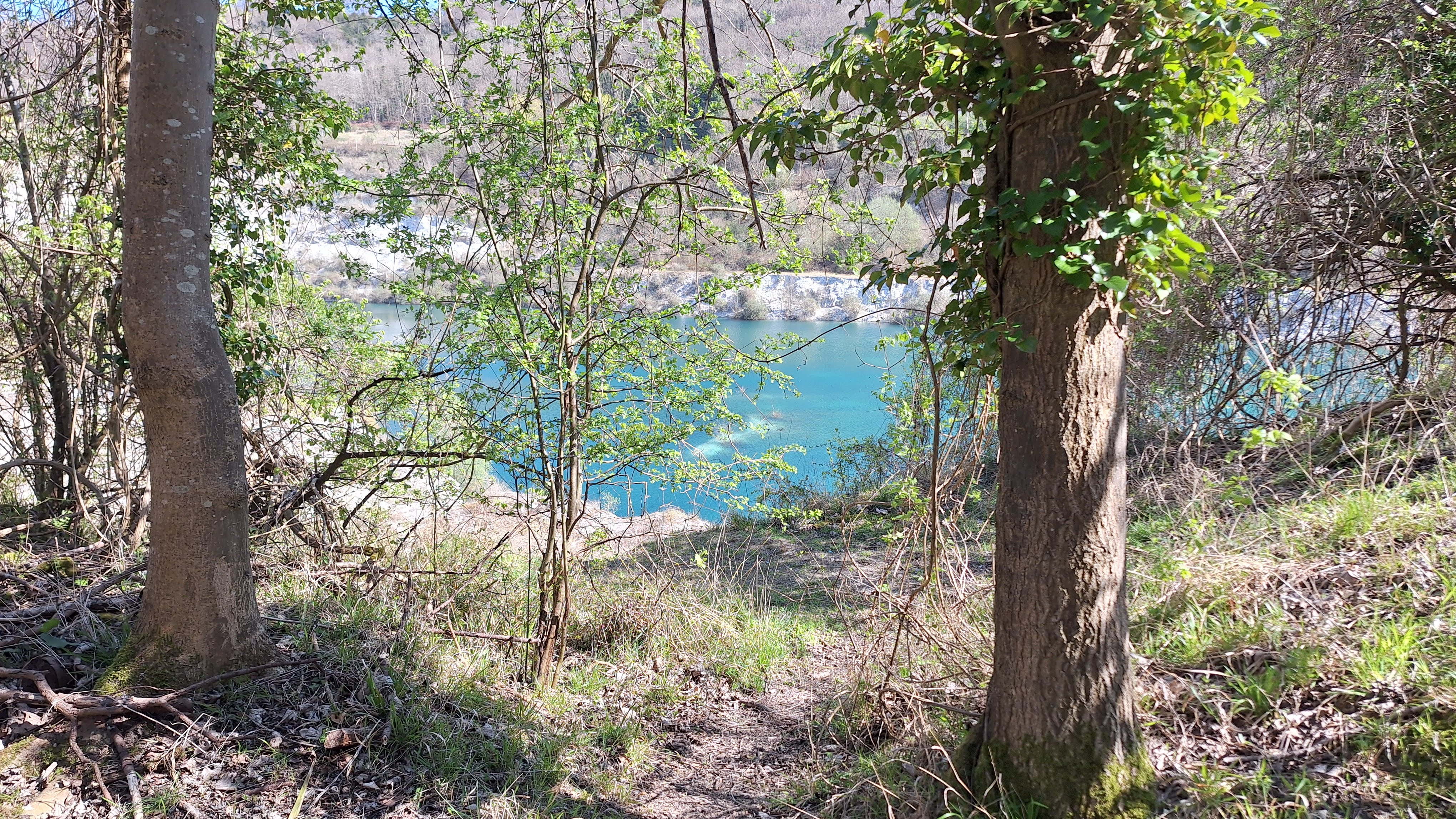
On ether side of the trackway at Chinnor one comes across perhaps the most remarkable sight on this walk, namely the abandoned chalkpits of the Chinnor Lime and Cement Works. The works finally closed around 2000, and the works chimneys, a landmark for miles around, were demolished in 2007. The three huge pits, two to the Northwest of the trackway, one to the Southeast have filled with water and are a turquoise blue. The pits are fenced off and surrounded by bushes, so sadly can only be glimpsed, except at the far end, where a gap in the fence allow access to the edge of the Southeastern pit. Enter at your own risk. The pits have been declared a geological Site of Special Scientific Interest.
 |
| Glimpse of Chinnor chalkpits |
The railway serving the works has been preserved as a heritage railway, which could transport walkers to Princes Risborough if the full walk proves too much.
Between Chinnor and Princes Risborough the trail scoops into the gap in the Chilterns, giving more open views over the surrounding countryside, culminating in the climb over Lodge Hill in the middle of the gap (though this climb may come as a sting in the tail for weary walkers).
 |
| Lodge Hill |
Logistics:
Start: On the A4130, adjacent to the Maker Space cafe and close to Nuffield Place (NT). This could be reached on the 33 bus from either Henley-on-Thames or Didcot Parkway Station, or (if you have stayed overnight at the White Hart Inn) from Nettlebed.
 |
| 33 bus at Nuffield Place bus stop |
Finish: Princes Risborough Station (trains to Marylebone and Aylesbury)
There is a bus (320) between Chinnor and Princes Risborough Station, but it seems to run only early mornings and evenings (probably a rail bus for commuters). Buses from Chinnor to High Wycombe might also be a possibility.
Distance: 16.5 miles, including the walk to Princes Risborough Station.
 |
| Princes Risborough Station |
Challenges:
This leg is quite long, but there seem no public transport options in between. If you happen to do the walk on one of the days when the Chinnor Railway is running (check website), you could cut up to the Chinnor terminus, and catch the train to Princes Risborough, making 11 miles.
The Trail sometimes seems to belie its name (Ridgeway) by perversely staying at the foot of the Chilterns scarp rather than following the ridge. I guess this is because the scarp is here not so well pronounced as the Ridgeway West of the Thames, and in places where it might be, the obvious route is now a road, or there is simply no public right of way.
The trackway is popular with cyclists. I've no problem with that, I'm a cyclist myself, but I wish they would ring their bell if they approach from behind. Sometimes I jump out of my skin when they appear silently from nowhere.
The Bledlow Cross marked on OS maps a short climb off the trail is a chalk 'figure' which used to be visible from some distance. However, it now seems to be overgrown, and not worth the effort of searching for it.
Refreshments:
The Maker Space cafe next to the bus stop on the A4130 at the start of the walk.
Tea caravan in Nuffield Place.
Pub in Lewknor, just before the M40 subway, if you are prepared for a 0.7 mile excursion (one-way).
Plenty of options in Princes Risborough.
 |
| Maker Space cafe |
Nearby Walks:
For an overview map of all my walks along the Ridgeway East of the Thames see this page.
Previous section: Goring to Nuffield Place
Next section: Princes Risborough to Wendover
For cycling the Ridgeway West of the Thames as part of the King Alfred's Way: this blog describes cycling the whole King Alfred's Way, with links to more detailed blogs for the Ridgeway sections.
More Photos
Bright day in April
 |
| Climbing to Ewelme Park |
 |
| Ewelme Park House |
 |
| Blossom in garden |
 |
| Garden gates |
 |
| Polo ponies? |
 |
| Swyncombe Park |
 |
| Swyncombe Park |
 |
| Church Lane, Swyncombe |
 |
| May blossom |
 |
| Fields |
 |
| The long straight trackway |
 |
| Copas Farms alternative path outside hedgerows |
 |
| Beacon Hill, on the other side of the M40 |
 |
| Approaching M40 subway |
 |
| M40 Subway |
 |
| Aston Rowant NNR info board |
 |
| View from Aston Rowant |
 |
| Crossing the A40 (unremarkable, save for how quiet it is) |
 |
| Chinnor chalkpits |
 |
| Glimpse of chalkpit lake |
 |
| The upper end of the chalkpit |
 |
| You should see lots of red kites |
 |
| The views open out a bit after Chinnor |
 |
| Daffodils |
 |
| First dual signing with Icknield Way |
 |
| Path over to Lodge Hill |
 |
| Path to Lodge Hill |
 |
| View from Lodge Hill (Whiteleaf Cross chalk figure visible on the scarp) |
 |
| Woods on Lodge Hill |
 |
| Descent from Lodge Hill |
 |
| Crossing Great Chiltern Railway |
 |
| House on the way to PR Station (not on the Ridgeway) |
 |
| Railway crossing on the way to PR Station (not on the Ridgeway) |


Comments
Post a Comment