The Walk: This third leg of the Ridgeway East of the Thames starts where Leg 2 finished at Princes Risborough (PR) Station, and follows the Ridgeway to Wendover Station, including several fine viewpoints en route.
 |
| Coombe Hill |
Route
The Ridgeway walk is the BLUE line. The RED line is an optional excursion to Beacon Hill, an excellent viewpoint above the village of Ellesborough.
NB The map shows my route, with various diversions and excursions which you may not wish to follow precisely. You can download the Google map info, as a KML/KMZ file, then convert to GPX using a site like GPS Visualiser. The GPX for the entire Ridgeway can also be downloaded from the National Trails website.
It is a short walk from PR Station to join the Ridgeway. The route passes over Brush Hill (views) and Whiteleaf Hill (views); descends to the pub at Lower Cadsden (drinks); skirts Grangelands and Pulpit Hill Nature Reserve; emerges on the Kimble Grasslands (views); contours above the Chequers Estate; climbs through bluebell woods to the Boer War Monument on Coombe Hill (views); descends on downland to Wendover Station, with a short diversion (Spring 2025) over the HS2 railway works.
Why do it?
The first two legs of this Ridgeway journey (Goring-Nuffield Place, Nuffield Place-PR) might seem somewhat disappointing in terms of hills and views, having lengthy stretches along hedge-lined trackway and through woods. This Leg 3 however delivers more of what you might expect from a Ridgeway, traversing several hills with open tops and far reaching views (Burnt Hill, Whiteleaf Hill, the Kimble Warren, Coombe Hill, and the optional Beacon Hill).
 |
| Burnt Hill |
The Whiteleaf Hill scarp carries the eponymous chalk cross, which is most clearly seen from a distance. The earliest mention is 1742. One suggestion is that it was an ancient fertility symbol, to which the cross transept was added later in the interests of modesty!
 |
| Whiteleaf Cross from below |
At Kimble Warren, an attempt has been made to restore the chalk grassland which was common when the hills were grazed, but which has been allowed to revert to scrub in recent times. So many acres of our open downlands, and the associated panoramic vistas, have been lost in this way, and more restoration projects like this are required, not just in the Chilterns, but also on the North Downs (less so on the South Downs, where sheep grazing is still common).
 |
| Kimble Warren Restored Grassland |
From Kimble Warren, a spur extends Northwards to Beacon Hill. This is another excellent viewpoint, clear of trees, worth visiting if you have the time: it is about a 2.5 mile round trip excursion (RED line on the map). Details are given in this post.
 |
| View overlooking Ellesborough Church from Beacon Hill (optional) |
The route contours around the Chequers Estate. The large brick Chequers mansion was donated in 1921 by Lord Lee of Fareham to the nation to serve as the official country residence of the Prime Minister. Well manicured parkland surrounds the house, which is surprisingly open to prying eyes of Ridgeway walkers. Signs make clear that deviation from the path is not advisable, and you may assume that you are being watched and possibly recorded on CCTV.
 |
| Chequers |
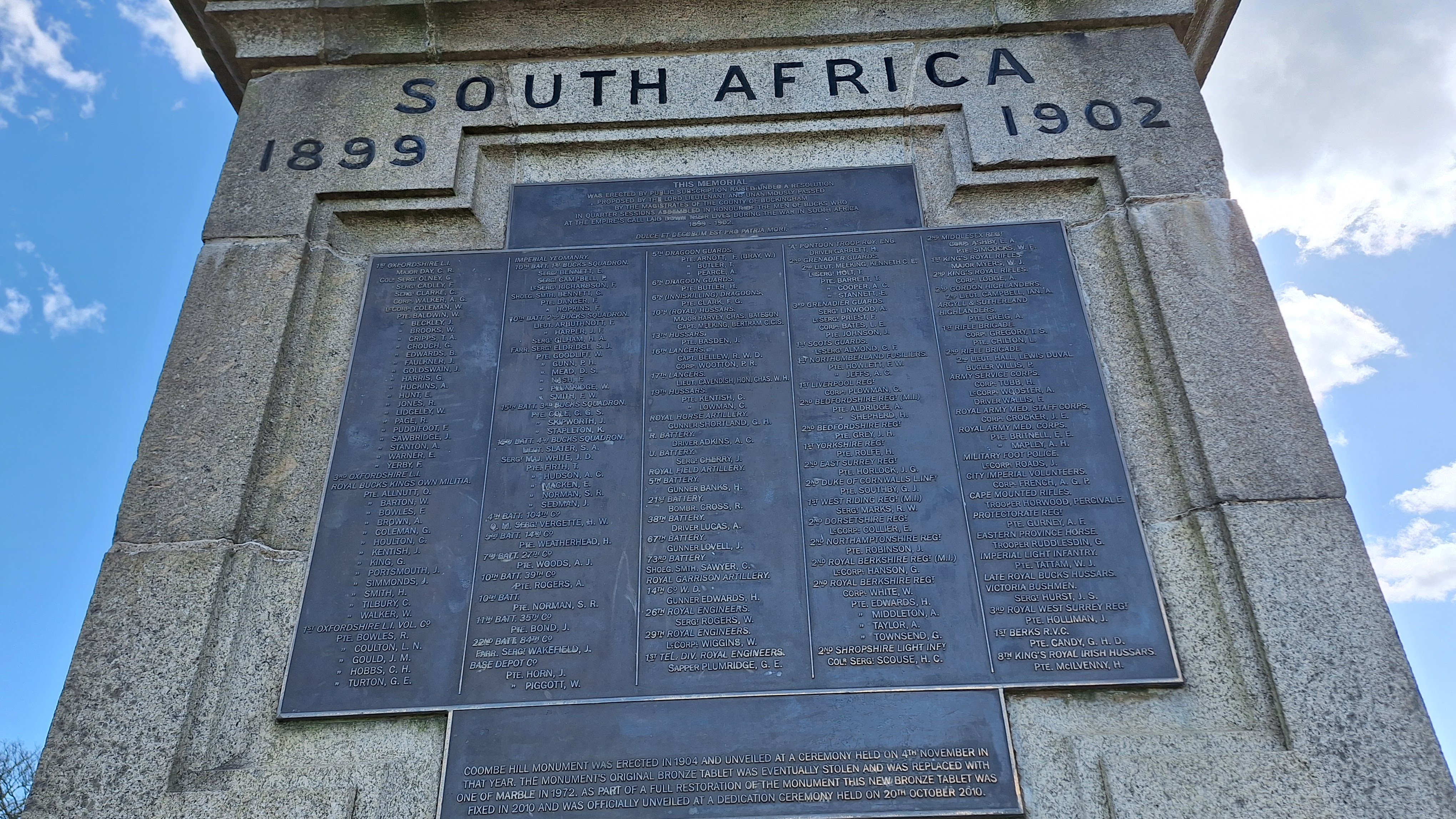
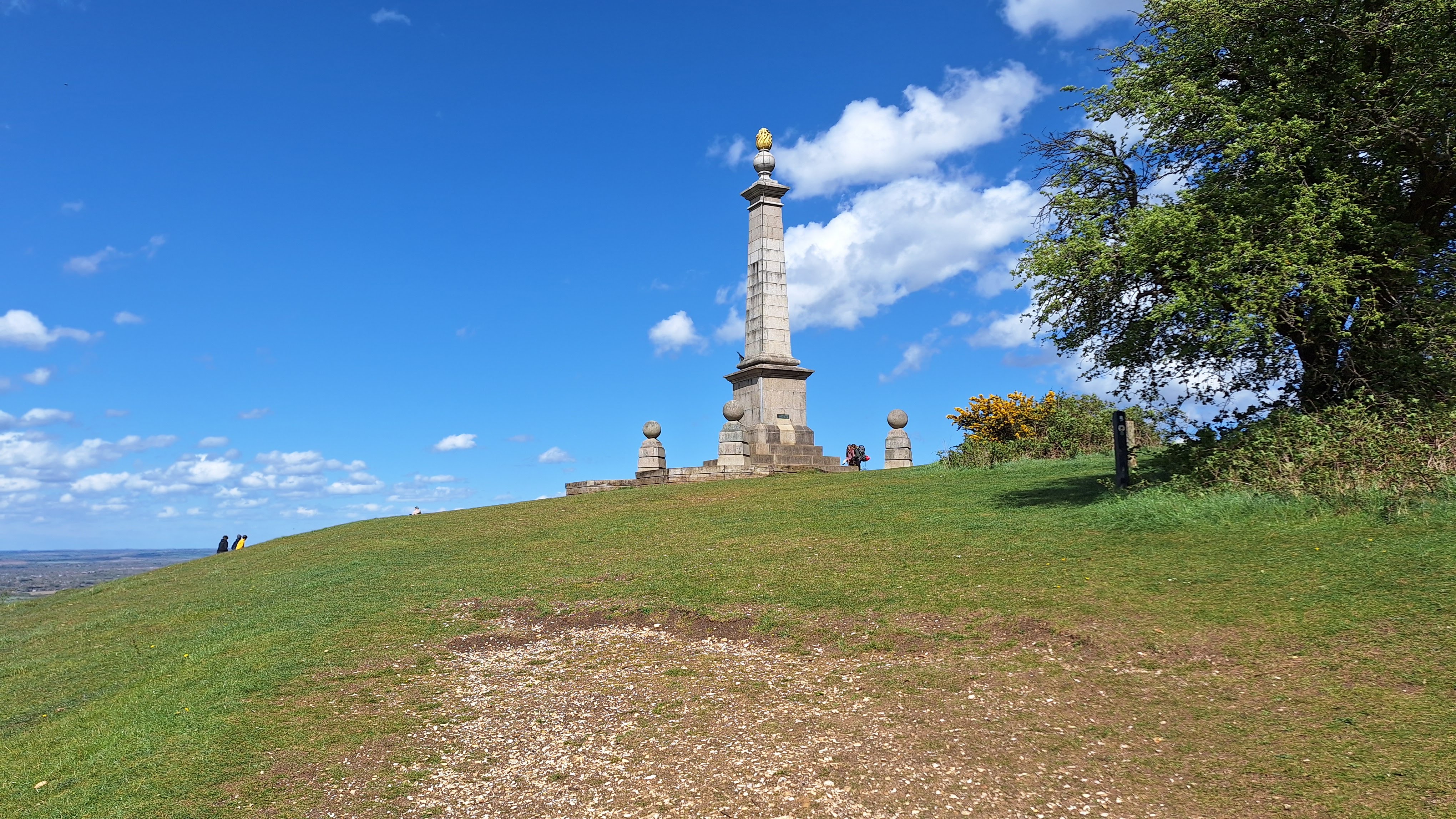
The high point of the walk - literally - is Coombe Hill, which is in the care of the National Trust, and at 852 feet, one of the the highest points in the Chilterns. Views over Aylesbury Vale and beyond are far reaching (including, it is said, the Cotswolds on a clear day). The hill is topped by a monument to the soldiers from Buckinghamshire who died in the Boer War. Some years ago, this had been allowed to fall into disrepair, and the bronze commemorative plaque had been stolen. Thankfully it has now been restored to its former glory.
 |
| Coombe Hill: Boer War Memorial |
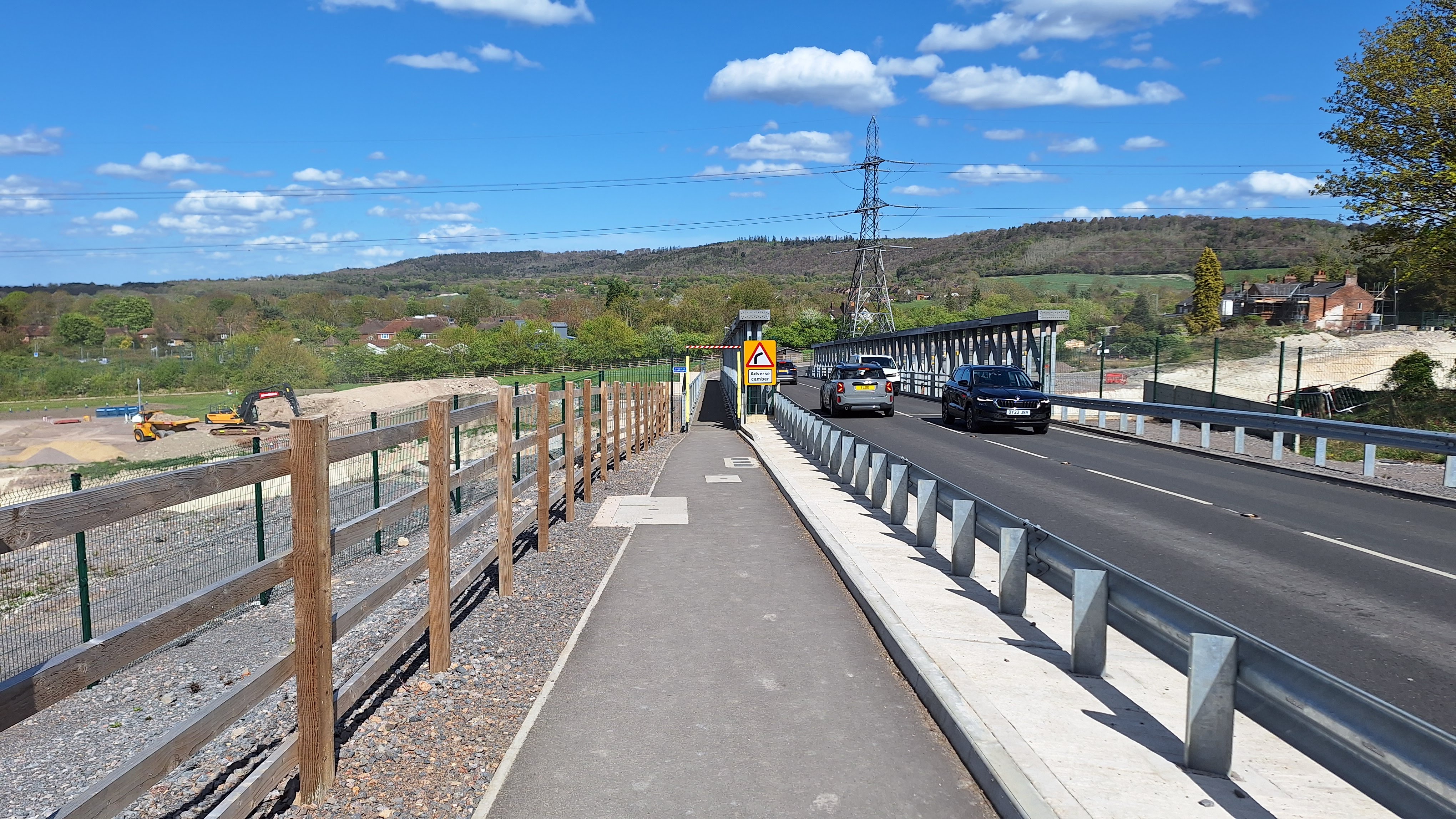
Visible from this summit, and crossed over on a new road in the final steps of the walk, is the linear scar of the HS2 Railway, currently (Spring 2025) under construction.
 |
| HS2 works crossing Aylesbury Vale |
In Spring, you should see bluebells in the woods en route.
 |
| Bluebells |
Logistics:
Start: Princes Risborough Station. Walk down Station Road and Poppy Road, then cross the A4010 to join the Ridgeway along Upper Icknield Way.
Finish: Wendover Station.
Both stations are on the Chiltern Line from Marylebone.
By car, you could park at PR Station (charge), and return from Wendover to that station via Aylesbury.
 |
| Top: PR Station Car park; Bottom: Wendover Station |
Distance: 8.5 miles, including the walk to join the Ridgeway from PR Station.
Challenges:
Like most hillside chalk figures, the Whiteleaf Cross is best seen from afar. Views from the hillside itself are limited.
 |
| Whiteleaf Cross from close up |
As already mentioned, just before reaching Wendover Station, the Ridgeway is subject to a short diversion onto a new road bridge whilst the HS2 works are ongoing.
 |
| HS2 Workings |
Signing of the Ridgeway was not quite so good as on Leg 1 and 2: rather than the word 'Ridgeway', many (not all) signs often use just the white acorn.
 |
| Watch out for the white acorn |
Refreshments:
Plenty of cafes etc in PR. The Connexions cafe, associated with the local Church, is run by volunteers, and has easy parking, good coffee and snacks.
 |
| Connexions Cafe |
The Plough at Lower Cadsden is conveniently situated right on the trail at an otherwise remote spot.
 |
| The Plough at Cadsden |
Buckmorend Farm Shop, on the Chequers Estate, has a coffee stall.
 |
| Buckmorend Farm Shop Kitchen |
Plenty of options in Wendover, including the Shoulder of Mutton pub right next to the station.
Nearby Walks:
For an overview map of all my walks along the Ridgeway East of the Thames see this page.
For cycling the Ridgeway West of the Thames as part of the King Alfred's Way: this blog describes cycling the whole King Alfred's Way, with links to more detailed blogs for the Ridgeway sections.
Previous leg: Nuffield to Princes Risborough
Next leg: Wendover to Tring Station
More Photos
Bright day in April
 |
| Join the Ridgeway at Upper Icknield Way |
 |
| Looking back to Lodge Hill on Leg 2 |
 |
| Brush Hill Nature reserve info board |
 |
| Steps up Brush Hill |
 |
| From Brush Hill looking across to Bledlow Cop |
 |
| Brush Hill Indicator (eg Wittenham Clumps 27.5km away) |
 |
| Brush Hill Indicator |
 |
| Shady seat on Brush Hill |
 |
| Bluebells |
 |
| Neolithic Barrow on Whiteleaf Hill |
 |
| View North from Whitleaf Barrow |
 |
| Whiteleaf Cross from hillside |
 |
| Whiteleaf Cross base |
 |
| View North from Cross: threatening clouds |
 |
| Much felled woodland, but at least it opens up the view |
 |
| The Plough at Cadsden |
 |
| Entry to Grangelands Nature Reserve |
 |
| Skirting Pulpit Hill |
 |
| Distant rain |
 |
| Exit from Grangelands Nature Reserve |
 |
| Tree |
 |
| Kimble Warren |
 |
| Kimble Warren Chalk Grassland Restoration info board |
 |
| Grass spur out to Beacon Hill |
 |
| Red Kite |
 |
| Chequers warning sign |
 |
| Chequers |
 |
| The path above Chequers |
 |
| Chequers with Coombe Hill monument behind |
 |
| Gates of Chequers |
 |
| Chequers Driveway |
 |
| Buckmorend Farm Shop inc coffee shack |
 |
| Chequers sentry box |
 |
| Track up Coombe Hill |
 |
| Bluebells |
 |
| Shoulder of Coombe Hill |
 |
| Coombe Hill overlooks Chequers |
 |
| Green spur is Beacon Hill |
 |
| Approaching Boer War Memorial atop Coombe Hill |
 |
| Boer War Monument |
 |
| View NW from Monument |
 |
| HS2 railway works |
 |
| Coombe Hill 'summit plateau' |
 |
| Path down from Coombe Hill |
 |
| Path down Bacombe Hill towards Wendover |
 |
| HS2 diversion signs |
 |
| New road crossing HS2 workings |
 |
| HS2 workings |
 |
| Shoulder of Mutton pub next to Wendover Station |


Comments
Post a Comment