The Walk:From Margate station, we rejoin the Coast Path where we left off. The walk mainly follows the sea wall, traversing the bays of the Thanet Coast resorts, the ruined Roman fort and medieval church at Reculver, the resorts of the self-styled Oyster Coast, and ending at the trendy harbour of Whitstable. The stations of the coastal railway line make it is easy to break the walk into shorter sections. To add variety to the otherwise relentless concrete tracks, my walk takes to the beach where possible.
 |
| Margate Surf Boat memorial (disaster 1897; statue 1899) |
Route
NB The map shows my route, with various diversions and excursions which you may not wish to follow precisely. You can download the Google map info, as a KML/KMZ file, then convert to GPX using a site like GPS Visualiser.
From Margate Station, walk down to the sea front next to the Nayland Shelter.
The official England Coast Path is then very easy to follow. Essentially, it follows the wide concrete track atop the coastal defences. To add variety, and give one's feet a break from the unforgiving surface, you can walk along beaches on the hard sand exposed at low tide. This works as far as Westgate (aka West) Bay.
Occasionally, one is diverted to the clifftop, perhaps most noticeably between Westgate Bay and Epple Bay, where the sea wall apparently continues, but reaches a dead end. However, at low tide, one may descend steps to the foreshore and make one's way gingerly around rocks, sea weed and rock pools into Epple Bay.
 |
| Beach, rounding the headland between West Bay and Epple Bay |
From Epple Bay to Minnis Bay, slippery rocks, rock pools and channels impede progress along the foreshore, so you must return to the wall.
At Minnis Bay, you may return to the sand, but beyond here, the beach becomes shingly and would be very hard going. So it's back to the sea wall between here and Reculver, which has a smooth tarmaced surface. In contrast to the rest of the walk, this section is very rural and devoid of habitation, presumably because the neighbouring land, formerly part of the Wantsum Channel which made Thanet an island, was too boggy for development.
From Reculver, having visited the impressive ruined church towers, and perhaps lingered over a cold drink in the King Ethelbert Inn, the official route will take you through Reculver Country Park and up and over the Bishopstone cliffs, but again, at low tide, a mainly sandy beach will take you round to the sea wall to rejoin the official path where it descends through Bishopstone Glen.
From here, through Herne Bay and all the way to Whitstable, the beaches are shingle and not good for walking, so best to stay on the sea wall, often behind or in front of beach huts.
From Whitstable Harbour, it is a short walk to the station.
Why do it?
After years of decline, the towns of the North Kent Coast have become quite fashionable. Margate has cultivated a bohemian image, with the Turner Contemporary as its centrepiece (see previous walk). The large sandy beach is overlooked by the brutalist Arlington Tower, in whose shadow is located the Nayland Shelter, wherein, a blue plaque tells us, T S Elliott was 'inspired' (if that's the right word) to write his poem 'The Wasteland'.
 |
| Nayland Shelter |
Whitstable Harbour has become a popular destination, and a foodie hangout.
 |
| Whitstable Harbour |
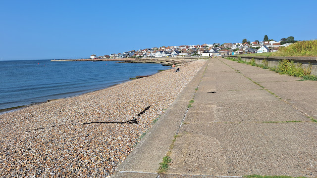
The coastal defences comprising miles of concrete sea walls at the base of the low chalk cliffs are an impressive feature in their own right: it is difficult to imagine such defences being built now without years of enquiries and consultation before the coast is abandoned to 'managed retreat'.
 |
| Sea wall |
The walk passes a sequence of sandy bays (Westbrook, St Mildred's, Westgate aka West, Epple and Minnis), backed by low chalk cliffs, and separated by a rocky chalk platform, with rockpools at low tide.
 |
| Westbrook Bay |
The coast and lagoons between Minnis Bay and Reculver constitute a Marine Protected Area and SSSI. Here was the northern end of the "River" Wantsum, the sea channel that separated the Isle of Thanet from the rest of Kent. It seems to have finally silted up by the late 16th Century. The Romans built the Regulbium Fort to defend the channel from Saxon raids (with Richborough its counterpart at the Southern end, as discussed in the Pegwell Bay walk). The two imposing ruined towers seen today are the remains of he 12th Century church of St Mary's, built within the ruins of the fort. The towers can be seen from as far away as West Bay, and it can seem to take an age to reach them.
 |
| Towers of St Mary's Church, Reculver |
If you chose to follow the official Coast Path through Reculver Country Park, there are good views looking back East to Margate as you climb the hill. The beach walk is overlooked by the crumbling Bishopstone cliffs.
 |
| Reculver Beach, backed by Bishopstone Cliffs |
Another prominent landmark which seems to take an age to reach is the clock tower on Herne Bay sea front, which is a memorial to the South African (Boer) War of 1899-1902. The town also boasts an art deco band stand pavilion, and a pier, which is the 'short' pier. The long pier was built to allow visiting steamers to disgorge passengers. Only the pier head survives, a strange island far out to sea.
 |
| Long Pier Head, from Short Pier, Herne Bay |
West from Herne Bay, the sandy bays and chalk cliffs of Thanet are replaced by one long shingle beach, giving the resorts of this self-styled Oyster Coast a different feel. Colourful beach huts line the shore. The Tankerton Slopes have been rewilded as a wild flower meadow.
 |
| Beach huts |
Throughout the walk, the sea is ever present, of course. On the proverbial clear day you might see the Essex Coast across the Estuary. From Reculver, the view ahead is dominated by the high ground on the Isle of Sheppey. There is also a massive offshore wind farm.
 |
| Long Pier Head, with Isle of Sheppey behind, and Clock Tower, Herne Bay |
On a hot day, pack your swimming costume and a towel, and cool off in the sea.
 |
| Cool! |
Logistics:
Start: Margate Station (car park, charge)
Finish: Whitstable Station (regular service back to Margate, or to London )
You can break the walk at several intermediate stations: Westgate, Birchington, Herne Bay, Chestfield and Swalecliff.
 |
| Car park, Margate station |
Distance: 18 miles
You might break the walk, for example, Margate-Herne Bay Station is 13 miles.
Challenges:
The concrete surface of the sea walls is hard on the feet, and can get rather boring, hence my attempt to walk on the beaches where possible.
That concrete surface however makes for an excellent traffic-free seaside bike ride, and away from the town centres, you will probably encounter many more cyclists than walkers.
 |
| Cyclists between Minnis Bay and Reculver |
The resorts and beaches are popular with day trippers, so go on off-season weekdays for a quieter experience.
If following the beach options, the usual health warnings apply: check tides, and watch out for slippery rocks and cliff falls and be prepared to get your feet wet.
 |
| Don't get cut off by the tide! |
Refreshments: There is no shortage of eateries of all sorts along the route. I called at the West Bay cafe right on the sea wall, the King Ethelbert Inn in Reculver, the King's Hall in Herne Bay, the Hampton Inn in Hampton; and the Hotel Continental in Whitstable for an evening meal (it was a long, hot, thirsty day).
Nearby Walks:
For an overview map of all my coast walks see this page.
Previous section: Ramsgate to Margate
Next section: TBD
As noted, this route makes an excellent cycle ride, designated the Viking Coastal Trail between Margate and Reculver, and the Oyster Bay Trail from Reculver to Whitstable, for more info, see my cycling blog.
More Photos
Very hot sunny day in midsummer
 |
| Blue Plaque to T S Elliott |
 |
| Margate Beach |
 |
| Arlington Tower |
 |
| Nayland Shelter |
 |
| Westbrook Bay |
 |
| West Brook Bay |
 |
| St Mildred's Bay |
 |
| Channels disect the beach |
 |
| Shady arcade at West Bay cafe |
 |
| Difficult foreshore |
 |
| Sea wall runs out at Westgate Bay |
 |
| End of the wall |
 |
| Epple Bay |
 |
| Beach is not easy to walk on between Epple Bay and Minnis Bay |
 |
| Reculver Towers on the far headland |
 |
| Pool at Minnis Bay |
 |
| Minnis Bay |
 |
| Looking back East on Minnis Bay Beach |
 |
| Info Board for MPA between Minnis Bay and Reculver |
 |
| The wall between Minnis Bay and Reculver |
 |
| Coldharbour Lagoon |
 |
| Wantsum info board |
 |
| Relic of the Wantsum |
 |
| Reculver Towers, getting closer |
 |
| Swimmers at Reculver Bay |
 |
| King Ethelbert Inn, Reculver |
 |
| Track down to Reculver Beach |
 |
| On Reculver Beach |
 |
| Path down from Reculver Country Park |
 |
| Herne Bay old pier head |
 |
| Herne Bay Clock Tower Boer War Memorial |
 |
| Amy Johnson was lost off Herne Bay |
 |
| Path behind beach huts |
 |
| Chinook |
 |
| Looking East to Hampton |
 |
| Path crosses Long Rock Nature Reserve |
 |
| Tankerton Bay Sailing Club |
 |
| Tankerton Slopes |
 |
| Whitstable Harbour |
 |
| Train arriving at Whitstable station |


Comments
Post a Comment