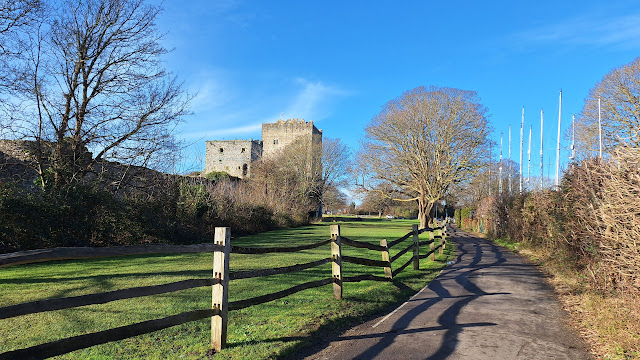
The Walk: After looking round historic Portchester Castle, follow the Northern 'Wicor' shoreline of Portsmouth Harbour, then make a circuit of the Cams Hall Peninsula to arrive at the outskirts of Fareham.
 |
| Mighty Roman walls of Portchester Castle |
Route
NB The map shows my route, with various diversions and excursions which you may not wish to follow precisely.
BLUE: main walk.
RED: extension to Fareham Bus Station
PURPLE: Shore Park return to start from White Hart bus stop
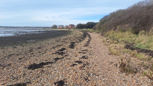
Start from the car park of Portchester Castle. Visit the castle courtyard if open. Then start the walk proper. Either join the sea wall just past the public toilets at the end of the car park, or head down Waterside Lane along the Northern perimeter wall of the Castle to reach the shore. There is then a good path following the massive turreted walls of the castle, and becoming the England Coast Path along the Northern shore of Portsmouth Harbour, known as the Wicor Shore, along a good concrete sea wall at first, then grassy swards and parks. At low tide, it is also possible to walk along the stony beach, which is handy when the shoreside path is muddy, or the path disappears behind bushes.
 |
| Path in front of Portchester Castle |
 |
| Stony beach |
The path finally turns back Eastwards following the Fareham Creek to emerge at the Cams Mill pub beside the A27. You can either get the No 3 bus back to Portchester from here, or (RED route) walk on along the other shore of the Creek to get the same bus back from Fareham bus station. Alight at the former White Hart pub in Portchester, and either walk back to the start along the coastal path (PURPLE route), or just walk directly down the road.
Why do it?
The massive outer walls of Portchester Castle date back to Roman times: it was one of the Saxon Shore forts. The Normans built an imposing Keep and church within the courtyard. The courtyard is free to access (including the Norman era church of St Mary's with its attached tea room.). The Keep is in the care of English Heritage, and there is an entrance charge.
 |
| Portchester Castle Keep |
There are good views over Portsmouth Harbour, including Northwards to the Trafalgar Shipyard, which often has interesting craft in dry dock, Portsdown Hill, where the most prominent feature is a structure built to emulate a Type 45 Destroyer, part of the BAe Systems Maritime Integration and Support Centre (MISC), Southwards to the RN Dockyard, where large warships will often be seen (the most distinctive being the Aircraft Carriers), and beyond to the Spinnaker Tower, and Westwards where the grass covered silos of the RN Ammunition Depot, Gosport can just be made out.
 |
| Trafalgar Shipyard and, behind, on Portsdown Hill, Type 45 Destroyer emulator |
At low tide, in winter, the muddy foreshore hosts large flocks of waders and Brent geese.
The Railway Viaduct crossing Fareham Creek is quite impressive.
 |
| Fareham Creek Railway Viaduct |
Logistics:
Start: Park in the large Portchester Castle car park (charge; public loos).
 |
| Portchester Castle Car Park |
Finish: Either at Cams Mill pub, or Fareham Bus Station. Either way, get the No 3 bus back to the former White Hart pub in Portchester (good regular service), and either walk back to the start along the coastal path (Purple line on the map), or just walk directly down the road.
You could bookend the walk by train using Portchester and Fareham stations, though this would add mileage.
Distance: 6 miles from Portchester Castle to the Cams Mill pub. Optional 1 mile to Fareham Bus Station. 0.7 miles back to start from White Hart bus stop. About 8 miles total all in.
Challenges:
Sections of the path flood at high tide, especially around Portchester Castle and near the Salt cafe. Notices show inland diversions, but it is best to do the walk at low tide.
The Wicor Shore path gets quite muddy: the mud can be avoided by walking on the stony beach, which again favours low tide.
 |
| Muddy path in parts |
Refreshments:
Tea room attached to St Mary's Church inside the castle courtyard (run by volunteers and accessible for free). Also, an al fresco coffee van by the courtyard entrance.
 |
| St Mary's Church Tea Room |
'84 By The shore' coffee stall in a converted domestic garage.
 |
| '84 By The Shore' coffee stall in converted garage |
Salt Cafe: up market cafe in boatyard with a wooden terrace right on the water front.
 |
| Salt Cafe has excellent waterfront location |
Dovecote Eatery in the Cams Hall Estate
Cams Mill pub at the entrance to the Cams Hall Estate
Nearby Walks:
For an overview map of all my walks along the South Coast see this page.
To the South: Hardway, Gosport, Stokes Bay
To the East: Eastney and Western shore of Langstone Harbour
For a cycle circuit of Portsmouth Harbour incorporating the current walk, see my companion cycling blog.
More Photos
January, bright at first, high cloud later
 |
| Path along sea wall |
 |
| Alternative down Waterside Lane |
 |
| Path beside castle walls |
 |
| Roman stonework |
 |
| More Roman stonework |
 |
| Coffee Van in courtyard |
 |
| Norman doorway, St Mary's Church |
 |
| St Mary's Church and Tea Room |
 |
| Coast Path leaving Portchester Castle |
 |
| Path along greens |
 |
| Path may be muddy in parts |
 |
| Spinnaker Tower, aircraft carrier to the right |
 |
| Grass covered ammunition silos of RNAD Gosport (difficult to see against the light) |
 |
| Beach alternative to muddy path |
 |
| Hulks near Salt Cafe |
 |
| Spinnaker Tower from near Salt cafe |
 |
| Defences at Wicor |
 |
| Boats moored in Fareham Creek |
 |
| Erosion at Wicor |
 |
| Beware golf balls on Cams Hall path |
 |
| Cams Mill and railway viaduct |
 |
| Coast path back to start |


Comments
Post a Comment