The Walk: This walk starts at Leysdown-on-Sea and heads down to the hamlet of Shellness, and then follows the Swale, the channel between Sheppey and the mainland, along the newly opened English Coast Path (ECP), passing through the Swale and Elmley Nature Reserves, and ending at the Kingsferry Bridge, convenient for Swale Station.
 |
| Beach shacks near Shellness |
Route
NB The map shows my route, with various diversions and excursions which you may not wish to follow precisely. You can download the Google map info, as a KML/KMZ file, then convert to GPX using a site like GPS Visualiser.
From the resort of Leysdown-on-Sea, walk along the beach to Leysdown Coastal Park. (If the tide prevents passage along the beach, follow the ECP signs along roads.) From here, follow the ECP and/or the beach to the hamlet of Shellness. Here the ECP turns Westwards through the Swale Nature Reserve. The path is along an embankment giving views over the salt marshes to the South and grazing marsh to the North.
The route then climbs inland passing Harty church and The Ferry House Inn then descending to the shore of the Swale again. Here, a new path takes you across the marshes and into the Elmley Nature Reserve.
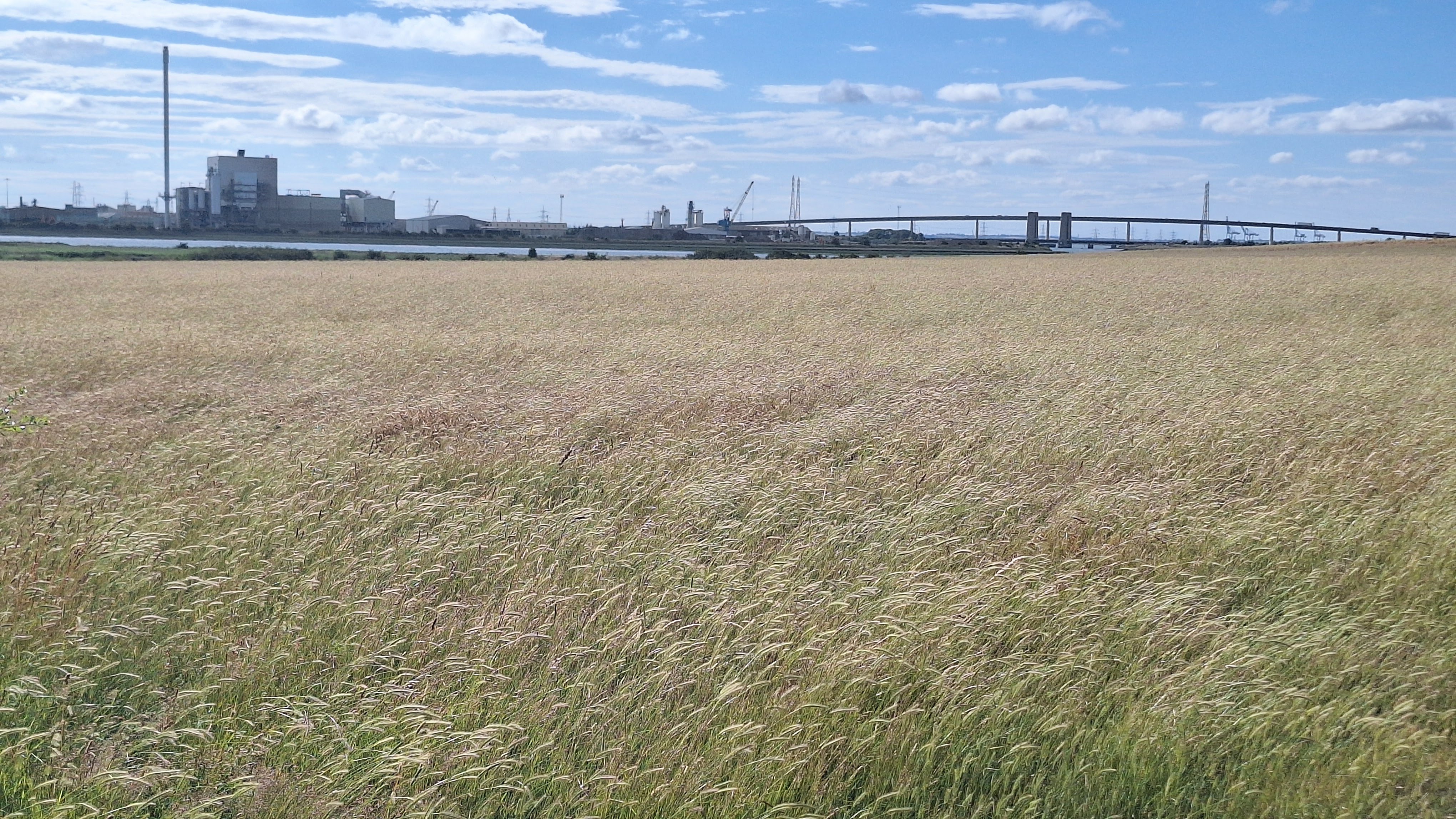
There is a long excursion around the Spitend 'peninsula' and the along to join the main track up to and through Kings Hill Farm, descending once again to the Swale, facing the factories, with their tall chimneys, on the opposite shore.
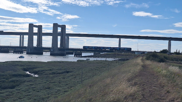
The 'new' road bridge over the Swale now looms ahead, dwarfing the old Kingsferry road/rail bridge in front of it.
The way across the Swale to Swale Station requires that you somehow get to the other side of the Kingsferry Bridge. The official route makes a two mile diversion via Straymarsh Farm. However, it is possible to scramble along the foreshore under the bridge. This is certainly possible at low tide, but of course don't attempt it if it is flooded.
 |
| Path through Swale NNR. Swale Channel in the distance, over the salt marsh |
Why do it?
The Isle of Sheppey sits at the mouth of the Thames Estuary. The North around the port of Sheerness-on-Sea is heavily populated and industrialised, the South is remarkably free from development, and includes two nationally important nature reserves (Swale and Elmley). The Island is 'cut off' from the 'mainland' by the Swale Channel, along which we walk. The Island was originally the 'Isles' of Sheppey, as it was made up of three islands: Sheppey, Harty and Elmley. The latter two constitute the high ground between which we walk on an otherwise flat path. Although superficially you might expect this walk to be rather dull, in reality there is much of scenic and natural interest.
We start on the Eastern end of the Island at the resort of Leysdown. The beach extends South, overlooked by park homes and beach huts, to the Leysdown Country Park, from where the beach is backed by open country.
 |
| Beach huts, Leysdown |
The upper beach is sandy, with extensive mudflats revealed at low tide. Out to sea, can be seen strange 'War of the Worlds' towers, which are anti-aircraft battery platforms erected in WW2, and also wind farms and the old pierhead of Herne Bay Pier, now an isolated island. Across the mouth of the Swale, the coast extends from Whitstable to Margate; it is possible to make out the twin towers of the ruined church at Reculver and the Artington Tower block in Margate (see this walk).
 |
| AA towers on left, wind farm on right |
Shellness is a private hamlet, which claims possession of the beach above the mean high water mark. Waders feed and nest on Shellness Beach.
 |
| Approaching Shellness hamlet |
The path through Swale National Nature Reserve follows the embankment, with salt marsh towards the Swale and grazing marsh inland. The reserve (along with Elmley) supports large wader and wetland bird flocks in winter. Also, the large areas of grassland support a large population of voles, which in turn provides prey for an unusually large number of raptors, especially marsh harriers and owls (barn and short-eared). I saw marsh harriers, but winter is probably the best time to visit for raptor watching (though the paths may then be very muddy), when large numbers of harriers fly in to roost in the grassland, especially well seen from the Capel Fleet viewing mound (not visited on this walk).
 |
| View over grazing marsh from Swale hide |
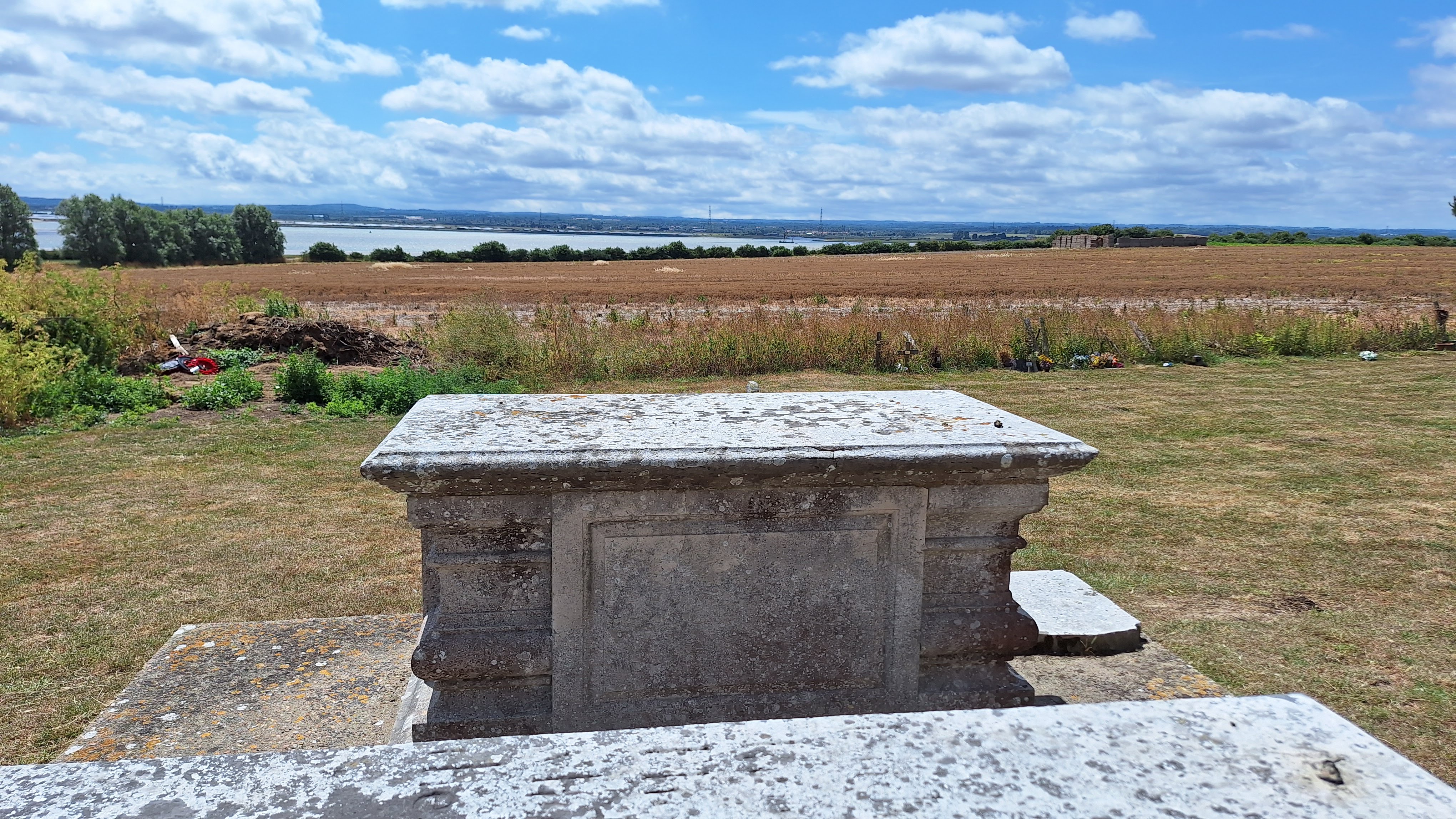
On Harty 'Island' between the Swale and Elmley Reserves you will find the Church of St Thomas the Apostle. From the churchyard, there are views out over the Swale. Also, the Ferry House Inn was the landing point for the Harty Ferry across the Swale to Faversham.
 |
| Tombs in Harty churchyard |
From the old ferry landing, a new path has been created as part of the ECP, linking the two reserves. The salt marsh was covered in purple sea lavender when I passed through in high summer. To the North you begin to see the buildings making up the three Sheppey prisons south of Eastchurch, and also some solar arrays and wind turbines.
 |
| Inauspicious start to new ECP |
After an excursion inland around Bells Creek and the Eastchurch Marshes (which are managed by the RSPB), we enter Elmley Nature Reserve. This is unusual as it is managed as a private reserve by the landowners based at Kings Hill Farm. They have their own distinctive style of fencing, rather more akin to a prison camp than a nature reserve.
 |
| Entrance to Stalag Luft Elmley |
The official ECP stays alongside but below the embankment, in order to avoid disturbing the wildlife, although this means your views over the Swale will be limited.
 |
| Start of long circuit of Spitend Peninsula |
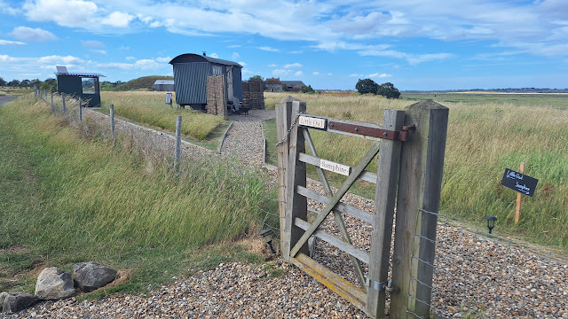
The ascent to and through Kings Hill Farm provides welcome long distance views. You can hire accommodation here, for example Shepherds Huts and Tents.
 |
| View from track up to Kings Hill Farm |
The final part of the walk between Kings Hill Farm and the Swale bridges has views to the various industrial works over the Swale - which are impressive in their way - and also to the modern road bridge soaring over the Swale, dwarfing its 1950's predecessor, the Kingsferry Bridge. The latter is a combined road and rail bridge, which can swing open to allow passage of large ships.
 |
| Factory and Swale road bridge |
Logistics:
Start: Leysdown-on-Sea (Rose and Crown bus stop)
Finish: Kingsferry road/rail bridge (for Swale Station)
This 18 mile walk is perhaps most conveniently accomplished in one go, which makes for a long day, and is hence best done in summer, making use of the Island's 'Chalkwell' bus network, together with the hourly railway shuttle from Swale Station to Sheerness-on-Sea.
I did it by parking at Tesco's Superstore in Sheerness-on-Sea (modest charge via the YourParkingSpace App for long term parking). I got the 0845 number 360 bus from the stand by the Tesco's car park to Leysdown (Rose and Crown), and walked down to sea front.
I arrived at Swale Station in time to catch the 1839 back to Sheerness (journey time just 10 minutes). You can also get the 334 bus from Swale Station to Sheerness. The train has the advantage that it runs until late, whereas bus services cease early evening.
By train, you could get to Swale or Sheerness-on-Sea via the railway shuttle service from Sittingbourne (trains from London Victoria or St Pancras).
 |
| Shuttle train leaving Swale |
Distance: 18 miles
If you could arrange transport to or from the Ferry House at Harty, you could split the walk into Leysdown-Harty 6 miles, Harty-Swale 12 miles.
Challenges:
As already noted, transport needs careful planning.
It is possible to walk along the beach from Leysdown to Shellness, for which low tide is best.
A stretch of beach approaching Shellness is designated for naturist bathing.
It is best not to try and reach the Shell Ness headland beyond the hamlet. Signs around the nature Reserve discourage it because of the risk of disturbing wading and nesting birds. Also, the beach in front of the Shellness houses is private above the mean high water mark.
 |
| Keep out zone on Shellness Beach |
The bridleway descending across a field from Harty Church to the Ferry House had been ploughed and planted over by crops: just cross through the crops in a straight line.
 |
| You need to tramp through this field |
The ECP track in the Elmley Nature Reserve is heavily overgrown by tall grasses at the Eastern end, especially around Spitend. This makes the walk around the Spitend Peninsula quite exhausting. Walking on the embankment is discouraged, so it is frustrating to know the Swale is just over the embankment but you are unable to see it. Anyway, the top of the embankment is equally overgrown. Long trousers are a good idea to reduce the tick risk.
 |
| Spitend: heavy going through the grass |
Elmley is a privately run nature reserve. People arriving by car are charged an entrance fee, with pre-booking required at busy times to control numbers, and the reserve is closed for extended periods. It is difficult to square this with access on public rights of way, especially the ECP. It seems that anyone entering on foot via these paths need not pay the fee, or heed any 'Closed' signs, but they should stick to the public rights of way, and not stray into the reserve proper (so for example the remote bird hides are out of bounds). Also, the rights of way other than the ECP seem de facto to be closed off in order to minimise disturbance, so you should stick to the ECP.
 |
| Footpath effectively out of bounds |
The last three miles from Kings Hill Farm to the Swale bridges have a backdrop of the factories on the far side of the Swale. I find them quite impressive, but they may not be to everyone's taste.
 |
| Works on opposite bank of Swale at Ridham |
Getting across to the other side of the Kingsferry road/rail bridge requires EITHER a long excursion northwards, OR a scramble under the bridge along the foreshore, which should not be attempted if it looks flooded.
 |
| Under the Kingsferry Bridge: take care! |
Refreshments:
There are several 'burger bar' type cafes in Leysdown. More appealing to through-walkers are the Garden Cafe in the Leysdown Coastal Park, or Neptune's Beach Cafe a bit further along.
The Ferry House at Harty is a quite posh full-service Inn.
When the Elmley reserve is open, Kings Hill Farm may provide snacks, but I'm not sure. They seem mainly to focus on pre-booked visitors for overnight stays, wildlife safaris, weddings etc.
 |
| Neptune Cafe |
Nearby Walks:
For an overview map of all my coast walks see this page.
For walking the rest of the Sheppey coast (West, North), see this post.
There is also a Harty Cycle Trail (see my companion cycling blog).
My Margate to Whitstable walk traverses the mainland coast visible from Shellness.
More Photos
Hot sunny day in late June
 |
| Parking at Tesco's Superstore, Sheerness-on-Sea |
 |
| Where the bus stops in Leysdown |
 |
| Leysdown |
 |
| AA towers |
 |
| Houses overlooking Leysdown beach |
 |
| Beach huts, Leysdown |
 |
| Garden Cafe |
 |
| Path south of Leysdown Coastal Park |
 |
| Beach shack |
 |
| Beach nearing Shellness |
 |
| Fuzzy zoom: Waders on Shellness beach. On the horizon I think we have (left to right) Herne Bay Old Pierhead, Margate tower block, Reculver twin church towers |
 |
| Swale salt marsh |
 |
| Lush grass |
 |
| Swale bird hide |
 |
| The track up to Harty |
 |
| Harty Church |
 |
| Greedy chicken tried to eat my lunch |
 |
| Descending to Ferry House |
 |
| Ferry house terrace |
 |
| Harty Ferry info board |
 |
| Ferry House |
 |
| Old Harty ferry landing |
 |
| New ECP |
 |
| Sea lavender |
 |
| Looks like duck boards in place for winter mud |
 |
| First sighting of Sheppey road bridge |
 |
| Looking back to Harty 'Island' |
 |
| Inland diversion around Bells Creek |
 |
| Wind turbines. Prisons ahead |
 |
| Elmley info board |
 |
| Heavy going through the tall grass around the Spitend peninsula |
 |
| Spitend Hide |
 |
| Thames barge on the Swale |
 |
| Glimpse of the Swale |
 |
| The path through the grass |
 |
| Swale |
 |
| Track to Kings Hill Farm |
 |
| View over the Swale |
 |
| Shepherds Hut |
 |
| Tent |
 |
| Works |
 |
| Brick debris on the Swale shore |
 |
| The two towers of the old bridge can be seen beneath the new |
 |
| Tall pylons carry cables over the Swale |
 |
| Train crossing the old bridge |
 |
| Foreshore under the Kingsferry Bridge |
 |
| Scramble under the bridge |
 |
| Emerge between the two bridges |
 |
| Lorry crossing on the new bridge |
 |
| Walk across the Kingsferry Bridge |
 |
| Entrance to Swale station |


Comments
Post a Comment